Measurements for archaeological research in Erbil/Iraq
Project partner
This project was created in cooperation with the German Archaeological Institute (DAI) in Berlin under the direction of Dr. Margaret van Ess and Dr. Arnulf Hausleiter.
Aim of the project
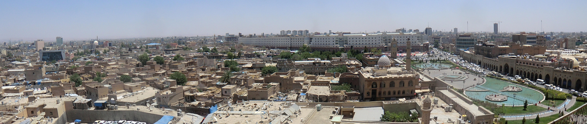
Since 2009, the German Archaeological Institute Berlin (DAI) has been allowed to carry out excavations and research in Erbil again. In the years 2009 - 2012 archaeological work in the urban area followed, which revealed evidence of pre-modern settlement remains. The task was therefore to obtain basic archaeological and topographical data, which can be used to verify the settlement development in the vicinity of the citadel of Erbil and in the so-called lower town.
As part of the DAI pilot project funded by the German Research Foundation (DFG), the Laboratory of Photogrammetry and Remote Sensing of the Faculty of Spatial Information has taken on the following tasks as a project partner:
- Determination of ground control points (GCP'S) with DGPS in the WGS84 coordinate system
- Transformation of existing local coordinate systems (profiles, building pits, excavations) into the WGS84 coordinate system
- Derivation of a high-resolution digital terrain model (DTM) from Pleiades stereo data
- Derivation of a city plan of the city of Erbil
Content
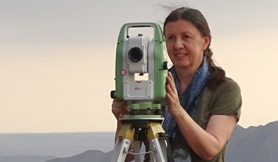
In June 2015, the first extensive GPS measurements took place in Erbil. Two Leica Viva Uno devices from Leica Geosystems were used.
On site in Erbil there is the permanent station "IRAQ SURVEY ERBIL" (short: ISER), which is operated by NOAA's National Geodetic Survey (NGS) as part of the CORS program (Continuously Operating Reference Stations). In principle, it is therefore possible to attach GPS measurements to this ISER permanent station. However, since there is no continuous data availability for the ISER station, a suitable reference point on the roof of the hotel in Erbil also had to be defined and determined.
This was followed by the measurement of control points as a basis for the georeferencing of the satellite images and the measurement of points for the transformation of the local coordinate systems (profiles, excavations, excavations) of the DAI.

In order to improve the georeferencing of the Pléiades data, contour control points were determined on site as part of the 2015 measurement campaign. With the help of these measured control points, it was possible to georeference the Pleiades stereo satellite data and then evaluate them stereoscopically. The aim was to derive a very precise digital terrain model (DTM).
All attempts at automatic DTM generation, including classification of the generated height points, delivered unsatisfactory results. Therefore, the decision was made to manually measure the entire DTM of Erbil. In a time frame of about 200 hours, Natalie Weigert (student assistant of the DAI at the Faculty of Geoinformation) created the DTM by manual stereo analysis. The Erdas Imagine software with the Imagine Photogrammetry tool was used for this work.

For the archaeologists from the DAI, knowledge of the height structure of Erbil is of particular interest. The measured DTM contains the height structure of Erbil at the time the Pléiades satellite data was recorded (January 2013). Although the buildings, vegetation, etc. were eliminated by manually recording the elevation data, the existing roads with their overpasses and underpasses, as well as larger excavation pits, were also recorded. After the results were presented and after consultation with the DAI, these elements had to be subsequently eliminated so that the original terrain structure becomes visible. From this, the archaeologists around Dr. Arnulf Hausleiter can already draw initial conclusions in relation to the settlement development of the city (course of the original city wall, etc.).

With the help of the digital terrain model, an ortho-satellite image could be generated, which represented the basis for the production of a satellite image map. This was created as part of a thesis.

Another task of the project is the transformation of the local measurements of the archaeologists of the DAI into the coordinate system WGS84. All excavations of the DAI are documented by local tachymetric recordings. In order to convert these into a uniform coordinate system, it was necessary to determine selected points from the local measurements using GPS in the WGS84 coordinate system. This was done as part of the 2015 measurement campaign. It was then possible to transform the tachymetric measurements.

A terrain model of the bazaar is of great interest to the archaeologists. Since the entire bazaar is covered by roofs, the DTM in this area cannot be derived from the satellite images. Thus, a local survey had to be carried out within the bazaar.
The local surveys took place in autumn 2018. The task turned out to be quite complicated, since entering the bazaar was only possible during opening hours and during this time the surveying work was severely hampered by the large number of visitors.
After extensive exploration, the area around the bazaar was first polygonized in a local coordinate system. Within the bazaar, the most important height points were then integrated into this local system by trigonometric height determination. A terrain model could then be derived from this and transformed into the coordinate system WGS84 using existing ground control points.
The DTM derived from satellite images could thus be completed in the area of the bazaar.