Prof. Dr. rer. nat. habil. Ulrich Walz
- Landscape Ecology
- Geographical Information Systems (GIS) I and II
- Landscape ecological internship
- Ecology / Environmental Protection
- Forecast & visualization of landscape changes
- Analysis and assessment of land use in the cultural landscape
- European Cultural Landscapes
Scientific interests
- Biodiversity and Ecosystem Services
- Landscape Change and Environmental Impacts
- Amphibians in the cultural landscape
- Landscape assessment with methods of remote sensing and GIS
- Indicators on landscape structure
- Development of large-scale protected areas
Chair
Landscape Ecology and Geographical Information Systems
Function
Dean of Studies Landscape Development (M.Sc.)
See also ResearchGate and Google Scholar
Selected publications since 2015:
2024
Walz, U. (2024): Wald und Gehölzstrukturen im Offenland im Kontext von Klimawandel, Biodiversität und Landschaftsbild. – In: Müller, C.; Meisch, S.; Ott, K.; Stadler, J.; Voget-Kleschin, L. & Potthast, T. [Hrsg.]: Wälder im Stress: Naturschutz im Wald unter sich radikal ändernden Bedingungen. Tagungsdokumentation der 21. Vilmer Sommerakademie. – BfN-Schriften, 695: 99-109; Bonn (Bundesamt für Naturschutz).
Walz, U. & Steinhardt, U. [Hrsg.] (2024): Landschaftsökologie. Von der Wissenschaft in die Praxis. – 1. Auflage 2024: 358 S.; Berlin (Springer Berlin Heidelberg).
Walz, U. (2024): Welche Landnutzung(sstruktur) brauchen wir? – In: Walz, U. & Steinhardt, U. [Hrsg.]: Landschaftsökologie. Von der Wissenschaft in die Praxis. – 1. Auflage 2024: 25-51; Berlin (Springer Berlin Heidelberg).
Hurtig, M.; Noritzsch, K.; Goldberg, R. & Walz, U. (2024): Modell ermittelt Standorte für die Entwicklung wertvoller Waldränder. – AFZ-Der Wald, (15): 26-30.
Walz, U. (2024): What Did the Cultural Landscape on Bornholm Look Like in the Mid-Eighteenth Century? An Analysis of Hammer’s Map. – KN - Journal of Cartography and Geographic Information, 74 (2): 121-135
Walz, U. & Eichler, L. (2024): Landschaft und Natur in Karten: Geschützte Flächen für Natur- und Artenschutz. – Naturschutz und Landschaftsplanung (NuL), 56 (6): 10-11.
2023
Grunewald, K.; Meier, S.; Syrbe, R.-U.; Walz, U. & Schweppe-Kraft, B. (2023): Ökosystemtypen und Monitoring der Flächenänderungen in Deutschland. – In: Grunewald, K. & Bastian, O. [Hrsg.]: Ökosystemleistungen. Konzepte, Methoden, Bewertungs- und Steuerungsansätze. – 2. Aufl.: 258-268; Heidelberg (Springer).
Meier, S.; Walz, U.; Syrbe, R.-U. & Grunewald, K. (2023): ÖSL „Bestäubungsleistung durch Wildbienen“. – In: Grunewald, K. & Bastian, O. [Hrsg.]: Ökosystemleistungen. Konzepte, Methoden, Bewertungs- und Steuerungsansätze. – 2. Aufl.: 290-296; Heidelberg (Springer).
Walz, U.; Richter, B.; Grunewald, K. & Syrbe, R.-U. (2023): Indikatoren zur Regulationsleistung von Auen. – In: Grunewald, K. & Bastian, O. [Hrsg.]: Ökosystemleistungen. Konzepte, Methoden, Bewertungs- und Steuerungsansätze. – 2. Aufl.: 369-378; Heidelberg (Springer).
Walz, U.; Schwarz, S.; Syrbe, R.-U.; Grunewald, K. & Meier, S. (2023): Naturbetonte Flächen und Naturschutzgebiete in Deutschland. – In: Grunewald, K. & Bastian, O. [Hrsg.]: Ökosystemleistungen. Konzepte, Methoden, Bewertungs- und Steuerungsansätze. – 2. Aufl.: 391-399; Heidelberg (Springer).
Krüger, T.; Lipfert, L. & Walz, U. (2023): Windkraftanlagen in Deutschland. Landschaft und Natur in Karten. – Naturschutz und Landschaftsplanung (NuL), 55 (03): 12-13.
Hou, W.; Liu, J. & Walz, U. (2023): Optimization of green infrastructure networks in the perspectives of enhancing structural connectivity and multifunctionality in an urban megaregion. – Journal of Environmental Management, 348: 119084.
Hou, W.; Zhai, L. & Walz, U. (2023): Identification of spatial conservation and restoration priorities for ecological networks planning in a highly urbanized region: A case study in Beijing-Tianjin-Hebei, China. – Ecological Engineering, 187: 106859.
Walz, U.; Paul, C. & Meier, S. (2023): Steinriegel und Steinrücken - Kulturlandschaftselemente und Lebensraum. Landschaft und Natur in Karten. – Naturschutz und Landschaftsplanung (NuL), 55 (11): 18-19.
2022
Walz, U.; Jaeger, J. A. G. & Haber, W. (2022): Argumente und Möglichkeiten für eine Quantifizierung und ein Monitoring der differenzierten Landnutzung. – Raumforschung und Raumordnung, 80 (5): 505-521.
Walz, U.; Meinel, G.; Göhler, L.; Krüger, T. & Schinke, U. (2022): Freiflächen-Photovoltaik in Deutschland. Landschaft und Natur in Karten. – Naturschutz und Landschaftsplanung (NuL), 54 (12): 8-9.
Grunewald, K., Syrbe, R.-U., Walz, U., Wende, W., Bastian, O., Meier, S., Zieschank, R. (2022): Nationale Indikatoren zur Bewertung von Ökosystemen und deren Leistungen – Bundesweiter Orientierungsrahmen für Landschaftsplanungen und Informationsgrundlage für die Bundespolitik. Naturschutz und Landschaftsplanung (NuL) 54, (2), 12–25.
Walz, U., Schumacher, U., Krüger, T. (2022): Landschaftszerschneidung und Waldfragmentierung in Deutschland - Ergebnisse aus einem Monitoring im Kontext von Schutzgebieten und Hemerobie. Natur und Landschaft 97, (2), 85–95.
2021
Meier, S.; Walz, U.; Syrbe, R.-U. & Grunewald, K. (2021): Indicators for pollination potential– The nationwide habitat potential for wild bees. In: Naturschutz und Landschaftsplanung (NuL) 53 (6), S. 12–19. DOI: 10.1399/NuL.2021.06.01.
Hou, W.; Zhai, L.; Feng, S. & Walz, U. (2021): Restoration priority assessment of coal mining brownfields from the perspective of enhancing the connectivity of green infrastructure networks. – Journal of Environmental Management, 277: 111289.
Roth, M.; Hildebrandt, S.; Walz, U. & Wende, W. (2021): Large-Area Empirically Based Visual Landscape Quality Assessment for Spatial Planning—A Validation Approach by Method Triangulation. – Sustainability, 13 (1891): 1-23.
Walz, U.; Wetzel, S. & Behnisch, M. (2021): Implementierung von Landschaftsstrukturmaßen zu Zersiedelung, Zerschneidung und Konnektivität in die Open-Source-Arcpy-Toolbox "Zonalmetrics". – GIS.Science, (1): 22-37.
2020
Grunewald, K.; Schweppe-Kraft, B.; Syrbe, R.-U.; Meier, S.; Krüger, T.; Schorcht, M. u. Walz, U. (2020): Hierarchical classification system of Germany’s ecosystems as basis for an ecosystem accounting – methods and first results. One Ecosystem 5 (3): 173.
Grunewald, K.; Schweppe-Kraft, B.; Syrbe, R.-U.; Meier, S.; Michel, C.; Richter, B.; Schorcht, M. u. Walz, U. (2020): Hierarchisches Klassifikationssystem der Ökosysteme Deutschlands als Grundlage einer übergreifenden Ökosystem-Bilanzierung. Natur und Landschaft 95 (03): 118–128.
Walz, U.; Pabst, L. u. Jentzsch, M. (2020): Mastfußflächen als Trittsteine? Zur Bedeutung isolierter Kleinstrukturen für den Biotopverbund in der Agrarlandschaft. Naturschutz und Landschaftsplanung 52 (7): 326–332.
Wende, W.; Walz, U. u. Stein, C. (2020): Evaluating municipal landscape plans and their influence on selected aspects of landscape development – An empirical study from Germany. Land Use Policy 99: 104855.
2019
Göhler, L.; Walz, U. u. Krüger, T. (2019): Entwicklung der Photovoltaik-Freiflächenanlagen in Deutschland - auf Grundlage des ATKIS Basis-DLM. In: Meinel, G.; Schumacher, U.; Behnisch, M. u. Krüger, T. (Hrsg.): Flächennutzungsmonitoring XI. Flächenmanagement - Bodenversiegelung - Stadtgrün. Rhombos. Berlin: 149–158.
Hennecke, D. u. Walz, U. (2019): Landschaftsstrukturmaße – Ein neuer Kursteil in OpenGeoEdu. GIS.Science (3): 98–109.
Hou, W.; Zhai, L.; Qiao, Q. u. Walz, U. (2019): Monitoring the intensity of human impacts on anthropogenic landscape: A mapping case study in Beijing, China. Ecological Indicators (102): 382–393.
Schliep, R.; Walz, U.; Sukopp, U. u. Heiland, S. (2019): Indicators on the Impacts of Climate Change on Biodiversity in Germany—Data Driven or Meeting Political Needs? In: Spangenberg, J. H. (Hrsg.): Scenarios and indicators for sustainable development - towards a critical assessment of achievements and challenges. MDPI. Basel, Beijing, Wuhan, Barcelona, Belgrade: 101–115.
Walz, U. (2019): Do we need 3D-landscape metrics? In: IALE (Hrsg.): IALE World Congress 2019. Book of Abstracts. July, 1-5 2019 Milano, Italy: 474.
Walz, U.; Richter, B. u. Grunewald, K. (2019): Indicators on the ecosystem service “regulation service of floodplains”. Ecological Indicators (102): 547–556.
2018
Hecker, S.; Luckas, M.; Brandt, M.; Kikillus, H.; Marenbach, I.; Schiele, B.; Sieber, A.; van Vliet, A. J.H.; Walz, U. u. Wende, W. (2018): Stories can change the world – citizen science communication in practice. In: Hecker, S.; Haklay, M.; Bowser, A.; Makuch, Z.; Vogel, J. u. Bonn, A. (Hrsg.): Citizen Science – Innovation in Open Science, Society and Policy. UCL Press: 445–462.
Inkoom, J. N.; Frank, S.; Greve, K.; Walz, U. u. Fürst, C. (2018): Suitability of different landscape metrics for the assessments of patchy landscapes in West Africa. Ecological Indicators 85: 117–127.
Schliep, R.; Walz, U.; Sukopp, U. u. Heiland, S. (2018): Indicators on the Impacts of Climate Change on Biodiversity in Germany - Data Driven or Meeting Political Needs? Sustainability 10 (11): 3959.
Stein, C. u. Walz, U. (2018): Indikator für ein Monitoring der landschaftlichen Attraktivität Deutschlands. In: Behnisch, M.; Kretschmer, O. u. Meinel, G. (Hrsg.): Flächeninanspruchnahme in Deutschland. Auf dem Wege zu einem besseren Verständnis der Siedlungs- und Verkehrsflächenentwicklung. Springer Spektrum. Berlin: 155–169.
Walz, U.; Schumacher, U. u. Krüger, T. (2018): Freiraumindikatoren im IÖR-Monitor – Stand und Entwicklung. In: Meinel, G.; Schumacher, U.; Behnisch, M. u. Krüger, T. (Hrsg.): Flächennutzungsmonitoring X. Flächenpolitik - Flächenmanagement - Indikatoren. RHOMBOS-Verlag. Berlin: 293–306.
Walz, U. u. Stein, C. (2018): Indicator for a monitoring of Germany’s landscape attractiveness. Ecological Indicators 94 (2): 64–73.
Walz, U. u. Syrbe, R.-U. (2018): Landscape indicators – Monitoring of biodiversity and ecosystem services at landscape level. Ecological Indicators 94 (2): 1–5.
Walz, U.; Wende, W. u. Stein, C. (2018): Landschaftsplanung eine Erfolgsstory? Ergebnisse aus dem DFG-Projekt: Analyse Landschaftswandel und Landschaftsplanung (LANALYS). In: Marschall, I. (Hrsg.): Landschaftsplanung im Prozess und Dialog. Beiträge zur gemeinsamen Fachtagung von BfN, BBN und FH Erfurt vom 27.03. – 29.03.2017 in Erfurt. Bonn-Bad Godesberg: 48–54.
2017
Burkhard, B. u. Maes, J. /Hrsg. (2017): Mapping Ecosystem Services. Pensoft Publishers. Sofia. 376 S.
Frank, S. u. Walz, U. (2017): Landscape metrics. In: Burkhard, B. u. Maes, J. (Hrsg.): Mapping Ecosystem Services. Pensoft Publishers. Sofia: 83–88.
Grunewald, K.; Syrbe, R.-U.; Walz, U.; Richter, B.; Meinel, G.; Herold, H. u. Marzelli, S. (2017): Germany’s Ecosystem Services – State of the Indicator Development for a Nationwide Assessment and Monitoring. One Ecosystem 2 (e14021): 1–18.
Grunewald, K.; Syrbe, R.-U.; Walz, U.; Richter, B.; Meinel, G.; Herold, H. u. Marzelli, S. (2017): Ökosystemleistungen Deutschlands. Stand der Indikatorenentwicklung für ein bundesweites Assessment und Monitoring. Natur und Landschaft 92 (11): 485–492.
Hou, W.; Neubert, M. u. Walz, U. (2017): A simplified econet model for mapping and evaluating structural connectivity with particular attention of ecotones, small habitats, and barriers. Landscape and Urban Planning 160: 28–37.
Pönitz, L.; Heinrich, U. u. Walz, U. (2017): Auenrenaturierung durch den Biber - Ermittlung von Vorrangflächen im Landkreis Mittelsachsen. Mitteilungen für sächsische Säugetierfreunde: 1–21.
Syrbe, R.-U.; Schröter, M.; Grunewald, K.; Walz, U. u. Burkhard, B. (2017): What to map? In: Burkhard, B. u. Maes, J. (Hrsg.): Mapping Ecosystem Services. Pensoft Publishers. Sofia: 151–158.
Walz, U.; Richter, B. u. Grunewald, K. (2017): Indikatoren zur Regulationsleistung von Auen. Ein Beitrag zum Konzept nationaler Ökosystemleistungs-Indikatoren Deutschland. Naturschutz und Landschaftsplanung 49 (3): 93–100.
Walz, U. u. Stein, C. (2017): Indikatoren für ein räumliches Monitoring des Landschaftswandels. In: Wende, W. u. Walz, U. (Hrsg.): Die räumliche Wirkung der Landschaftsplanung. Evaluation, Indikatoren und Trends. Springer Spektrum. Wiesbaden: 57–75.
Walz, U.; Syrbe, R.-U. u. Grunewald, K. (2017): Where to map? In: Burkhard, B. u. Maes, J. (Hrsg.): Mapping Ecosystem Services. Pensoft Publishers. Sofia: 159–165.
Wende, W. u. Walz, U. /Hrsg. (2017): Die räumliche Wirkung der Landschaftsplanung. Evaluation, Indikatoren und Trends. Springer Spektrum. Wiesbaden. 198 S.
Wende, W. u. Walz, U. (2017): Die räumliche Wirkung der Landschaftsplanung: Evaluation, Indikatoren, Trends – eine Einführung. In: Wende, W. u. Walz, U. (Hrsg.): Die räumliche Wirkung der Landschaftsplanung. Evaluation, Indikatoren und Trends. Springer Spektrum. Wiesbaden: 2–5.
2016
Grunewald, K.; Herold, H.; Marzelli, S.; Meinel, G.; Richter, B.; Syrbe, R.-U. u. Walz, U. (2016): Assessment of ecosystem services at the national level in Germany. Illustration of the concept and the development of indicators by way of the example wood provision. Ecological Indicators 70: 181–195.
Grunewald, K.; Herold, H.; Marzelli, S.; Meinel, G.; Richter, B.; Syrbe, R.-U. u. Walz, U. (2016): Konzept nationale Ökosystemleistungs-Indikatoren Deutschland. Weiterentwicklung, Klassentypen und Indikatorenkennblatt. Naturschutz und Landschaftsplanung 48 (5): 141–152.
Hou, W. u. Walz, U. (2016): An integrated approach for landscape contrast analysis with particular consideration of small habitats and ecotones. Nature Conservation 14: 25–39.
Jaeger, J. A. G. u. Walz, U. (2016): Fracking und Zersiedelung. In welchen Landschaften wollen wir leben? GAIA - Ecological Perspectives for Science and Society 25 (2): 73.
Walz, U.; Hoechstetter, S.; Drăguţ, L. u. Blaschke, T. (2016): Integrating time and the third spatial dimension in landscape structure analysis. Landscape Research 41 (3): 279–293.
Walz, U. u. Jaeger, J. A. G. (2016): Folgen von Fracking: Ein neuer Schub der Landschaftsfragmentierung ist zu erwarten. GAIA - Ecological Perspectives for Science and Society 25 (2): 99–104.
2015
Jaeger, J. A. G. u. Walz, U. (2015): Die verfrackte Landschaft. Ist von Fracking die Rede, sorgen sich die meisten zuerst um das Grundwasser. Ein anderer Aspekt wird oft vergessen: die Folgen für die Landschaft vor unserer Haustür. ZEIT online.
Bastian, O.; Grunewald, K.; Leibenath, M.; Syrbe, R.-U.; Walz, U. u. Wende, W. (2015): Landscape Services. In: Grunewald, K. u. Bastian, O. (Hrsg.): Ecosystem Services - Concept, Methods and Case Studies. Springer. Berlin: 65–69.
Grunewald, K.; Walz, U.; Herold, H. u. Syrbe, R.-U. (2015): Ökosystemleistungen erfassen und bewerten. Erste Vorschläge für die nationale Ebene in Deutschland. Naturschutz und Landschaftsplanung 47 (10): 305–310.
Hou, W. u. Walz, U. (2015): Incorporation of ecotones and small habitats in landscape structure analysis: a case study from Saxon Switzerland, Germany. In: Thinh, N. X. (Hrsg.): Modelling and Simulation of Ecosystems. Workshop Kölpinsee 2014. Rhombos. Berlin: 243–255.
Lausch, A.; Blaschke, T.; Haase, D.; Herzog, F.; Syrbe, R.-U.; Tischendorf, L. u. Walz, U. (2015): Understanding and quantifying landscape structure – A review on relevant process characteristics, data models and landscape metrics. Ecological Modelling 295 (1): 31–41.
Łowicki, D. u. Walz, U. (2015): Gradient of Land Cover and Ecosystem Service Supply Capacities - A Comparison of Suburban and Rural Fringes of Towns Dresden (Germany) and Poznan (Poland). Procedia Earth and Planetary Science 15: 495–501.
Petroschka, M.; Schanze, J.; Luther, J.; Walz, U. u. Vogel, R. (2015): Verfügbarkeit ausgewählter Ergebnisse in einem webbasierten Entscheidungsunterstützungswerkzeug. In: Schanze, J.; Schwarze, R.; Horlacher, H.-B. u. Deilmann, C. (Hrsg.): Veränderung und Management der Risiken extremer Hochwasserereignisse in großen Flussgebieten. Am Beispiel der Elbe. Schweizerbart. Stuttgart: 351–359.
Walz, U. (2015): Indicators to monitor the structural diversity of landscapes. Ecological Modelling 295 (1): 88–106.
Walz, U.; Grunewald, K.; Herold, H.; Richter, B.; Syrbe, R.-U.; Meinel, G. u. Marzelli, S. (2015): Bundesweite Indikatoren zu Ökosystemleistungen. In: Meinel, G.; Schumacher, U.; Behnisch, M. u. Krüger, T. (Hrsg.): Flächennutzungsmonitoring VII. Boden - Flächenmanagement - Analysen und Szenarien. Rhombos. Berlin: 279–288.
Wende, W.; Stein, C. u. Walz, U. (2015): Impact of Landscape Planning on Land Use and Landscape Structure. In: IALE WORLD CONGRESS 2015 – Technical presentation abstracts. Portland.
Wirth, P.; Walz, U. u. Scharfe, S. (2015): Öffentlichkeitsbeteiligung bei der Konzeptentwicklung in Großschutzgebieten. Spielräume und Restriktionen am Beispiel des Landschaftsschutzgebietes Sächsische Schweiz. Naturschutz und Landschaftsplanung 47 (3): 86–92.
Education
- Habilitation 2013 (University of Rostock)
- Promotion 2000 (TU Dresden)
- Studies of Geography and Landscape Ecology (1988-94) in Stuttgart and Hohenheim
Professional carreer
- Chair of Landscape Ecology at Dresden University of Applied Sciences (HTW) (since 2015)
- Research stay at the Concordia University, Department of Geography, Planning & Environment, in Montreal, Kanada (10-11/2014)
- Private lecturer at Rostock University (since 2013)
- Head of the professional group "Landscape ecology and Landscape planning" at IÖR (since 2011)
- Lectureships at Technical University Dresden, Rostock University and Dresden University of Applied Sciences (since 2002)
- DAAD Research scholarship at the VÁTI Magyar Regionális Fejlesztési és Urbanisztika Társaság, Budapest in Ungarn (2002)
- Project manager at the Leibniz-Instutite of Ecological Urban and Regional Development (IÖR) (since 1995)
- Employee at an office for landscape planning in Waiblingen, 1992-95
- Meißner, B. (2021): Konzeption von Artenhilfsmaßnahmen für Amphibien im Bereich zwischen Perleberg und Wittstock (Dosse) in Brandenburg. HTW Dresden; Dresden: 98 S.
- Bronold, L. (2020): Untersuchung und Bewertung möglicher Reproduktionsgewässer des Feuersalamanders (salamandra salamandra) im unteren Einzugsgebiet der Biela. HTW Dresden; Dresden: 68 S.
- Gille, M. (2020): Stillgewässerkartierung und Habitat-Eignungsanalyse am Beispiel drei ausgewählter Amphibienarten (Wechselkröte, Rotbauchunke und Springfrosch) im Stadtgebiet Pirna und Umgebung (Messtischblatt-Quadrant 5049-NO).
- Schäfer, L. (2019): Der Feuersalamander (Salamandra salamandra) im Struppenbachgrund - Erfassung und Digitalisierung der Lebensräume und Gefährdungsanalyse
- Trentzsch, K. (2019): Populationsschätzung und -entwicklung des Feuersalamanders (Salamandra salamandra) im Struppengrund (LSG Sächsische Schweiz).
- Pabst, L. (2018): Kleinstrukturen in der Agrarlandschaft – Am Beispiel von Mastfußflächen im Untersuchungsraum Mittelsachsen
- Bertram, S. (2018): Die Amphibienverbreitung im Raum Döbeln (Sachsen) unter Berücksichtigung der Gewässer- und Landnutzung
- Schu, A. (2018): Charakterisierung von Kleingewässern und qualitative Erfassung ihres Amphibieninventar im MTB- Quadrant 4949 SW
- Kelling, T. (2018): Kleingewässer und Amphibienvorkommen im Messtischblatt 4949, Quadrant 3
- Drescher, H. (2017): Entwicklung von möglichen Ausgleichsmaßnahmen zum Schutz und Erhalt gefährdeter Amphibienarten im Raum Freiberg, Sachsen
- Pönitz, Lisa (2016): Auenrenaturierung durch den Biber – GIS-basierte Ermittlung von Vorrangflächen an Gewässern 2. Ordnung im Landkreis Mittelsachsen
- Müller, Thomas (2015): Untersuchung des Zusammenhangs zwischen der Landschaftsstruktur und dem Vorkommen dreier Vogelarten
Reviewer
- among others for the magazines "Landscape and Urban Planning", "Ecological Indicators", "Living Reviews in Landscape Research", "Landscape online" and "GIS Science"
- for the German Research Foundation (DFG)
Memberships
- Board member of International Association of Landscape Ecology (IALE) - Regional Chapter Germany
Current Research Projects
The Königsbrücker Heide nature reserve is sizuated approx. 30 km north of Dresden. Since the foundation of the military training area (TÜP) Königsbrück in 1907, the landscape has changed fundamentally. The traditional cultural landscape with its settlements and associated open country was reshaped by the military use until unrecognizability. After the military training area was abandoned, the area now designated as a nature reserve developed into one of the largest wilderness areas in Germany.
The aim of the research is to build up a geodatabase to land-use change in historical times and to the natural conditions. Building on this, spatial analyzes are to be carried out.
Therefore, current developments in the landscape can be better understood if it is known which natural conditions such as geological ground, soils, etc. exist at a certain point, but also what uses were previously there. Was there forest or grassland, arable land or something completely different even before it was used as a military training area?
Client: Staatsbetrieb Sachsenforst; NSG-Verwaltung Königsbrücker Heide/Gohrischheide Zeithain

The fire salamander, which is at great risk in Saxony, mainly occurs in the catchment area of the upper Elbe River. This area includes in particular the Saxon Switzerland and the Dresden Elbe valley as well as the directly adjacent areas of the Mulde-Loess Hills and the Eastern Ore Mountains. In Saxon Switzerland, the fire salamander is a rarely observed but characteristic species. In detail, however, there are gaps in the knowledge of the specific occurrence and the population sizes at the individual waters. This is where the work starts.
Link to the online recording of fire salamanders in Saxon Switzerland.
Publications:
Trentzsch, K.; Walz, U.; Schäfer, L. & Phoenix, J. (2021): Der Feuersalamander (Salamandra salamandra) in der Nationalparkregion Sächsische Schweiz - Populationsschätzung und Gefährdungsursachen im Struppengrund bei Pirna. – Naturschutzarbeit in Sachsen, 61: 14-37.
Completed Theses:
Trentzsch, K. (2019): Populationsschätzung und -entwicklung des Feuersalamanders (Salamandra salamandra) im Struppengrund (LSG Sächsische Schweiz). HTW Dresden.
Schäfer, Lisa (2019): Der Feuersalamander (Salamandra salamandra) im Struppenbachgrund - Erfassung und Digitalisierung der Lebensräume und Gefährdungsanalyse. Bachelorarbeit. HTW Dresden, Dresden.
Cooperations:
Nationalparkverwaltung Sächsische Schweiz
Sächsische Landesstiftung Natur und Umwelt, Nationalparkzentrum Bad Schandau

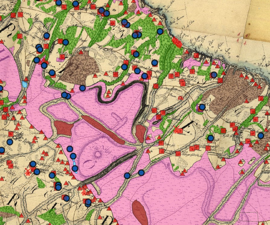
The island of Bornholm in the Baltic Sea has undergone major landscape changes over the last 250 years, which have had an impact on the shape of the landscape and its functions (agriculture, recreation, biodiversity). In this study, Hammer's historical maps from the 1750s were processed and analysed using GIS technology. The results were mapped and analysed according to the individual land use types and cultural landscape elements. For example, 250 years ago there was a very large proportion of extensively utilised heathland and very little woodland, which is exactly the opposite today. In addition, there were a large number of smaller landscape elements, which together created a diversely structured, agriculturally utilised landscape. This also includes the many smaller still waters as well as wetlands and moors.
The large number of recorded defence installations, such as redoubts, batteries, fortifications and signal points, clearly show the military significance of the map and the importance of such installations for the security of the island at that time. The large number of windmills and water mills, farms and churches were also recorded. The results are also available digitally and interactively to the public.
Further information:
Publication:
Walz, U. (2024): What Did the Cultural Landscape on Bornholm Look Like in the Mid-Eighteenth Century? An Analysis of Hammer’s Map. – KN - Journal of Cartography and Geographic Information, (1). doi: 10.1007/s42489-024-00161-1

Biodiversity in the Central European cultural landscape continues to decline. The amphibian species group is also particularly hard hit. The scientific objectives of this project are:
- Development of the basis for a scientifically sound monitoring programme for selected test plots
- To gain knowledge about the connections between land use changes and the development of amphibian populations.
- Derivation of recommendations for action for the interconnection of water bodies and wetlands.
Completed Theses:
- Gille, M. (2020): Stillgewässerkartierung und Habitat-Eignungsanalyse am Beispiel drei ausgewählter Amphibienarten (Wechselkröte, Rotbauchunke und Springfrosch) im Stadtgebiet Pirna und Umgebung (Messtischblatt-Quadrant 5049-NO). HTW Dresden; Dresden: 60 S.[Bachelorarbeit].
- Schneeweiß, J. (2019): Erfassung und Analyse der Stillgewässerstruktur im Raum Königstein/Sächsische Schweiz (MTBQ 50503). HTW Dresden; Dresden: 73 S.[Bachelorarbeit].
- Bertram, S. (2018): Die Amphibienverbreitung im Raum Döbeln (Sachsen) unter Berücksichtigung der Gewässer- und Landnutzung. HTW Dresden; Dresden: 47 S.[Bachelorarbeit].
- Kelling, T. (2018): Kleingewässer und Amphibienvorkommen im Messtischblatt 4949, Quadrant 3. HTW Dresden; Dresden: 60 S.[Bacheloarbeit].
- Schu, A. (2018): Charakterisierung von Kleingewässern und qualitative Erfassung ihres Amphibieninventar im MTB- Quadrant 4949 SW. HTW Dresden; Dresden.[Bachelorarbeit].
Publications:
Bertram, S.; Walz, U. & Günther, A. (2020): Amphibien in Agrarlandschaften Mittelsachsens. Zum Einfluss von Landnutzung und Strukturreichtum in der Umgebung von Laichgewässern auf die Besiedlung durch Amphibien [Amphibians in agricultural landscapes in central Saxony – the influence of land use and structural richness in the vicinity of spawning waters on colonisation by amphibians]. – Naturschutz und Landschaftsplanung, 52 (08): 368-377.
Cooperations:
Nationalparkverwaltung Sächsische Schweiz
Landesamt für Umwelt, Landwirtschaft und Geologie (LfULG)
Development and implementation of a methodology for the nationwide recording and evaluation of ecosystem services as part of the implementation of Objective 2 and Measure 5 of the EU biodiversity strategy.
Processing together with the Leibniz Institute for Ecological Spatial Development on behalf of the Federal Agency for Nature Conservation.
Completed Research Projects
On behalf of the Federal Agency for Nature Conservation, the "Habitat diversity and landscape quality" indicator was developed as part of the overall project at the HTW.
With the help of four sub-indicators, the habitat diversity and landscape quality at the district level are assessed. Diverse landscapes are seen as a prerequisite for species protection in climate change and as an expression of climate change-resilient landscapes. The four sub-indicators developed are the “diversity of use and land cover classes”, the “proportion of areas less influenced by culture”, “small-scale connectivity of landscape elements” and the “borderline density of water- and wood-dominated habitats”. The total value of the diversity of habitats and landscape quality for a district results from the combination of the sub-indicators using an assessment matrix.
For a nationwide statement on habitat diversity and landscape quality, two indicators were created from the sub-indicators mentioned:
- Distribution of the area proportions of the state / federal area for five assessment levels (very low, low, medium, high and very high)
- Proportion of area in the state / federal area on which the indicator has at least medium ratings (i.e. medium, high and very high ratings)
Client: Federal Agency for Nature Conservation
Cooperation Partner: Technical University Berlin
Publications:
- Schliep, R.; Walz, U.; Sukopp, U. u. Heiland, S. (2018): Indicators on the Impacts of Climate Change on Biodiversity in Germany - Data Driven or Meeting Political Needs? Sustainability 10 (11): 3959. Schliep, R.; Walz, U.; Sukopp, U. u. Heiland, S. (2018): Indicators on the Impacts of Climate Change on Biodiversity in Germany - Data Driven or Meeting Political Needs? Sustainability 10 (11): 3959. doi: 10.3390/su10113959

Development of an explanatory model for municipal landscape planning effectiveness using land use and landscape structure monitoring indicators